Ben Nevis Navigation
Thousands of people climb Ben Nevis every year and the vast majority make it back down safely. However there are accidents every year and this information aims to reduce the number of incidents which occur due to errors in navigation.

During periods of good visibility the navigation is relatively straightforward but as soon as the mist comes down the plateau can be an extremely confusing and frightening place, especially under conditions of snow and ice. Sound map and compass skills along with a little forethought will go a long way towards avoiding the epics which the unprepared often experience, sometimes with disastrous consequences.
To have a fighting chance of navigating effectively on Ben Nevis it is essential to be armed with at least one map, with a waterproof cover, and a decent compass. Opinions vary as to the best maps for Ben Nevis. It is important to have a map which covers all possible descent routes down to low ground so that there is no chance of "walking off the map". It is also very useful to have a large-scale map on which the north face, Coire Eoghainn and Five Finger Gully can be clearly seen. Three maps are rightly popular:-
- Ordnance Survey Ben Nevis (Sheet 41) 1:50,000 scale
- Harvey Superwalker Ben Nevis 1:25,000 scale
- Harvey Ben Nevis Summit 1:12,500 scale (useful for showing the summit area)
A map without a waterproof cover is a liability; so invest in a map case.
Beware of having the map case on a cord around your neck. This may be OK when there is no wind but the summit plateau is no place to indulge in kite flying with a spinning map around your neck. Having the map fastened around your neck also makes it difficult to orientate or set the map.
A compass for mountain navigation should have a relatively large baseplate, a magnifying glass, measuring scales or romers, rubber feet for gripping the map and be useable with gloves or mitts.
Always take a map and compass
Locating the summit
On the ascent of the main mountain track from Glen Nevis, the navigation often becomes more difficult as you get higher. The summit plateau has few definite features, the weather and visibility may have deteriorated, snow may cover the track and the route gets closer to the gullies of the north face as you approach the summit.
Keep track of your position on the map right from the beginning of your ascent.
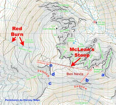
Count the corners on the zigzags and then estimate the distance you have travelled by using timing and pacing. There is a significant steepening (McLean's Steep) between 500 and 600 metres distance west of the summit. It is easy to become disorientated on this final section. Careful use of timing and pacing from McLean's Steep will help.
Beware of the tops of Tower Gully and Gardyloo Gully cutting in from the north. There is a major change in direction once the top of Gardyloo Gully has been passed (see the bearings and distances in the next section which deals with descending from the summit - in ascent use back-bearings). Failure to identify this change of direction can leave you wandering around on the steep ground above Coire Leis or Coire Eoghainn (see A & B on the map extract). The summit can be positively identified by a large cairn and concrete trig point and also the emergency shelter which is on a raised platform of stones (see pictures on 'The Summit'). The summit cairn is very close to the north face - so take care. The emergency shelter is just a few metres south of the summit cairn and further away from the edge of the north face.
If you become disorientated during the ascent of Ben Nevis, consider whether it may be best to turn back. Ben Nevis will always be there - the important thing is to make sure you are too.
Navigating down from the summit
The Harvey Ben Nevis Summit map 1:12,500 scale clearly shows the bearings and distances. From the summit cairn follow a Grid bearing of 231 degrees for 150 metres. Beware of the steep drop into Gardyloo Gully on your right. Remember to make the correct adjustment for the magnetic variation (in 2009 add 3 degrees so that the bearing becomes 234 degrees).
You will also need to confidently pace the distance. Practice pacing on lower and less serious terrain before using it on Ben Nevis. If you have a rope of known length, you can use this to measure the distance.
Once you have completed this leg and passed the top of Gardyloo Gully, turn onto the second Grid bearing of 282 degrees. Remember the magnetic variation (in 2009 add 3 degrees so that the bearing becomes 285 degrees). It is often this next section that goes awry.
After travelling 300 metres on fairly flat terrain there is a steeper section for about 100 metres (McLean's Steep) before the angle eases again. There is a natural tendency to steer very slightly to the left of the bearing in order to keep away from the north face. This is entirely understandable and may even be a wise precaution under certain conditions. The effect that this slight deviation can have is to put you onto the steep and potentially fatal ground at the top of Five Finger Gully. Being forewarned is to be forearmed and the knowledge that Five Finger Gully lurks below you to the south-west is an important piece of information to keep in mind.
The edge of Five Finger Gully is about 800 metres from the top of Gardyloo Gully from where the 282 degree Grid bearing begins. Careful attention to pacing and timing will keep you informed about how far you have travelled. If, after about 800 metres from the top of Gardyloo Gully, you reach steep ground dropping away to the west, southwest or south then you have strayed into the top of Five Finger Gully (see C, D & E on the map extract). If you find yourself travelling south downhill with a cliff edge on your right (west) you have veered off the bearing significantly...
"THE ILLUSTRATIONS ARE NOT SUFFICIENT BY THEMSELVES FOR SAFE NAVIGATION ON BEN NEVIS. A PROPER MAP AND COMPASS ARE ESSENTIAL. PRACTICE NAVIGATION ON LOWER AND LESS SERIOUS TERRAIN BEFORE RELYING ON YOUR SKILLS ON BEN NEVIS."
Extract from Harvey Ben Nevis Summit map
- The details on this page should be read in conjunction with your map as part of your prior planning. Make sure it all makes sense to you before you set off - it won't be any easier when you get up there!
To get back on course you will have to go right (north) until you have skirted the top of Five Finger Gully. This might involve going uphill. It's obviously important that you don't travel north for too long, otherwise you may end up close to the edge of the north face. Once the top of Five Finger Gully has been avoided (it spans about 500 metres) you can revert to the 282 degree Grid bearing which will take you down towards the zigzags and the track which eventually turns north towards Lochan Meall an t-Suidhe. Be careful not to stray into the Red Burn which has steep sections and can be avalanche prone in winter.
Navigating off when you haven't been to the summit
This can be more difficult because you may not have a definite start point. You may have decided to turn back because of deteriorating visibility and conditions or you may have topped out on a climb on the north face a long way from the main summit.
When turning back, the navigation will be easier if you have been following your progress on the map so that you have a clear idea of your location. If you know where you are it should be relatively easy to follow the bearings described in the previous section.
The situation is more difficult if you are not sure of your position - it is not possible to prescribe a simple remedy which will allow for all possibilities. If you can be sure that you have not reached a point higher than 1200 metres (on the mountain track from Glen Nevis) a reasonable decision may be to set your compass to 282 degrees Grid (285 degrees Magnetic in 2009) and follow the bearing.
- Beware of going into the Red Burn which has steep drops and possible avalanche danger.
If you are higher than 1200 metres and unsure of your location, the solution is more complicated. If there is no snow or ice and the visibility is sufficient to enable you to avoid walking over the edge, it should be possible to follow the 282 Grid bearing and take avoiding action if you reach steep ground or a cliff edge. If you find yourself at the edge of the north face you may be able to follow the edge until it is possible to get back onto the bearing. The top of Five Finger Gully may be less obvious and it may be necessary to go uphill before getting back onto the bearing (see the last paragraph in the previous section). You can use "aspect of slope" to help identify steep ground or cliff edges which you have arrived at. Take a bearing with your compass of the direction in which the ground is dropping away and then look at the map to find areas of steep ground which match this bearing. This only takes a few moments and is well worth doing anytime that you are on or near steep ground and unsure of your location.
- It is much better to avoid getting lost by keeping track of your position during the ascent by ticking off the corners on the zigzags and then estimating distance travelled by timing and pacing.
If you have topped out on a climb it is useful to have done the calculations before reaching the plateau, especially if the wind is strong. The north face is often protected from the prevailing southwesterlies but the winds can be fierce on the exposed plateau. The Harvey Ben Nevis Summit 1:12,500 scale map is very useful and weighs almost nothing. You will be able to identify your position on the map and plot a course which will take you onto the 282 degree Grid bearing. It's worth checking the guidebook to see whereabouts on the plateau your climb tops out. A few minutes research prior to doing the climb can be repaid a thousand times later in the day and may even be a lifesaver.
Following the path
The path will often provide a useful navigational "handrail" but be aware that it does not lie directly along the bearings described above. You may have to make a decision to either follow the path or follow the bearing. If the path is obscured by snow it may be better to follow the bearing. Remember that the path often goes closer to the north face than the 282 degree Grid bearing and that there are several paths. One path goes quite close to the top of Five Finger Gully. If you are following the path, keep a check on the compass bearing too.
GPS (Global Positioning System)
Using a GPS receiver can be a useful addition to the essential map and compass skills, especially if you enter the relevant waypoints prior to your journey. The Harvey Ben Nevis Summit 1:12,500 scale map is ideal for use with GPS and has a 100 metre grid superimposed on it which enables accurate Grid References to be taken. Useful waypoints to enter include the corners of the zigzags, the 1200 metre contour where the path bifurcates, McLean's Steep and the junction of the 282 and 231 degree Grid bearings near the top of Gardyloo Gully. Remember that following a GPS receiver does not necessarily take you on a straight line in the same way that a traditional compass can - an important point on the Ben Nevis plateau. GPS is a navigational aid but not a substitute for map and compass skills.
This page reproduced with the kind permission of the Mountaineering Council of Scotland (MCofS). They run a number of Mountain safety courses, Seminars and Lectures. You can join the MCofS here